Services
Overview
Airborne Imaging has performed LiDAR and Aerial Photo projects from the far reaches of Alaska and the Mackenzie Delta in the north to the southern tips of Texas, Louisiana and Alabama. To date, we have successfully completed over 3,000 projects throughout North America with elevation maps and LiDAR data using Airborne lasers.
Our LiDAR data clients
We are proud to have over 500 different clients in several industries requiring Airborne laser mapping data including the oil and gas, mining, legal survey, engineering, power, and government sectors. Many of our projects are standalone and exclusive, however many use our LiDAR Library for their project needs. Their continued patronage and support is the foundation of what makes Airborne a successful company, today.
Our LiDAR survey and elevation mapping experience
Airborne currently has 7 project managers on staff specializing in mapping services using LiDAR surveys to produce elevation maps. These individuals all have thousands of field hours of mapping experience and can manage the logistics and technical challenges for any type of project. They have all managed many tens of thousands of square miles of LiDAR data collection, GPS/IMU post processing and point cloud calibrations.
In addition, our LiDAR Operators have all operated and flown thousands of square miles of LiDAR surveys, each. All of our operators are versed in operating both Optech and Leica LiDAR systems and can be moved to a project anywhere, seamlessly.
Lastly, our processing group has processed over 700,000 square kilometers of LIDAR in North America in the past 10 years. Our collection of Geomatics, Surveying and mapping specialists, have been the reason over 3,000 projects have been delivered on budget and on time. It’s been the cornerstone of Airborne to deliver in the time frame and within the budget we promise.
Industry Services
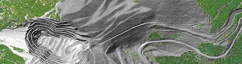
Mining
Get detailed maps for mineral exploration, monitoring and mine remediation/reclamation. We deliver data for volume calculations, slope analysis, and identifying potential hazards, including flow accumulation risk for tailings ponds. Our LiDAR sensor technology allows us to penetrate thick canopy to provide accurate and quality ground points which is unmatched by other systems. LiDAR is a vital tool in determining value in your assets, planning, construction and efficiency in infrastructure and operations.
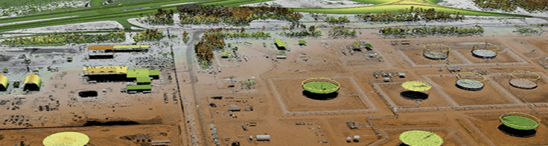
Oil and gas exploration
The energy sector is comprised of many facets from on-shore and off-shore exploration, development, pipeline operations, environmental and risk mitigation and even reclamation. With unmatched safety, experience, and professionalism, Airborne the company to meet all your oil and gas exploration and operational needs. For services ranging from regularly scheduled pipeline patrol, geospatial needs for exploration/seismic and planning and development of roads and well pads, and for flow accumulation and remediation/reclamation work, Airborne has highly experienced team members to handle the project.
What we offer:
- Terrain mapping for well pad and road design
- Geohazard identification and monitoring
- Vegetation encroachment on ROW
- Vegetation classification
- Erosion detection for depth of cover
- Wide area mapping for seismic programs
- O&G infrastructure remediation
- Slope analysis
- Flow accumulation/spill modelling
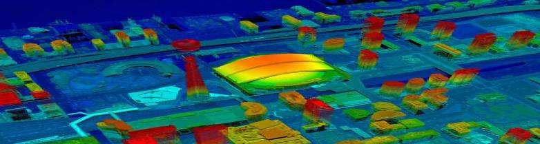
Engineering
Experience the highest level of precision and accuracy in your projects with our mapping services. We deliver the point density, pulse spacing, and vertical accuracy required for any application, including civil engineering, heavy construction, urban planning, transportation, etc. Our expertise and equipment allow us to deliver LiDAR Quality Level (QL0) and higher, ensuring unparalleled results when accuracy matters. Plus, with simultaneous collection of aerial imagery, we provide a complete picture of the area, facilitating planning and seamless communication with stakeholders. Airborne can also provide detailed planimetric or vector feature mapping to support digital twins of all your needs.
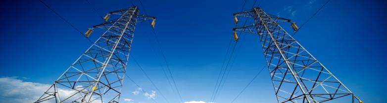
Power
Aiborne Imaging has acquired LiDAR data for new transmission line corridors, hydro-electric and Dam sites, and wind energy farms. These power solutions have used the accurate digital terrain models from Airborne LiDAR acquisition to model route locations, plant sites, water flow modeling and turbine locations.
Airborne has also managed combined LiDAR and Imagery projects for these applications. High resolution imagery combined with high density LiDAR gives the client the best perspective to make sound decisions. The speed of LiDAR acquisition and DEM generation allows faster preparation of ortho-images and much shorter delivery times.
Environment
Flood mapping has long been the number one use of LiDAR throughout the world. Areas of high risk, such as The Red River Basin in the Dakotas and Southern Manitoba, US Gulf States and many coastal regions have been using LiDAR for modeling risk and contingency planning since its inception in the mid 1990’s. LiDAR has the ability to acquire large flood areas, at high density within days. In emergency situations, the data can be processed and delivered within days.
LiDAR has seen its uses for environmental impact studies rise dramatically in recent years. The affects of broken dikes, pipeline blow outs, spill management etc. have led to using LiDAR DEM’s for calculating slope, view shed analysis, water and wind flows to determine affects on communities and stakeholders in the event of catastrophe.